|
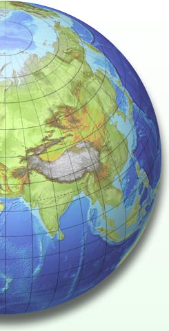
Geo-Globes - A mile-stone in Earth imagery
Geo-Globes gives you accurate print resolution maps, specially compiled and designed for easy customising by the graphics, publishing and media industries.
Perfect for book covers, atlas pages, airline maps, globe locations, web maps, multi-media and Power-Point presentations, exhibitions and illustrations.
All available in a simple 2 DVD set of Photoshop documents, copyright free and ready to go.
Already used by some of the worlds leading publishers.
As well as rivers, lakes,borders, bathymetry and graticules - just look at these unique features.
- A staggering 6.4 gig of information.
- More viewpoints than ever before, including 15 special views of Europe.
- Larger images, (and therefore higher resolution) than anything else on the market.
At 300 DPI each image is 11 inches wide, (28cm approx).
- Unique digital height masks included with every image, for customising the relief enhancement.
- Six different colourings.
- 100,000 or more combinations as standard.
- Created by internationally renowned cartographers.
- All images entirely copyright free.
|
|