 |
|||||||||||
 |
|||||||||||
|
|
|||||||||||
|
|||||||||||
|
|||||||||||
|
|
|||||||||||
|
||||||||||||||||||||||||||||||
 |
||||||||||||||||||||||||||||||
|
MINISTERIAL BRIEFING MAPS |
||||||||||||||||||||||||||||||
|
Ministers, senior civil servants and managers of large organisations, often have to assess material from many sources at short notice, and must be confident that their brief is not only accurate, but can also be grasped with the minimum of effort. |
||||||||||||||||||||||||||||||
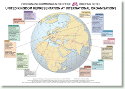 |
Maps and graphics, in these instances, should be self explanatory, without the need for cross-referencing or elaborate legends. For many years Geo-Innovations has specialised in this branch of cartographic visualisation. As a result, in 2005, Geo-Innovations was asked to create a wide range of new briefing maps, for the UK Foreign and Commonwealth Office, to assist Ministers involved in promoting the national interest. The project involves creating clear and concise maps for every country in the world, thematic mapping on subjects of special interest, and rapid response mapping in emergencies. |
|||||||||||||||||||||||||||||